Locast Travels Wearable Gadget
From
Locast Travels ---
Locast wearable is a mobile medium that provides visitors during their
trip with alternative navigation experiences through its
visual and haptic interfaces and functions like digital souvenir to
keep an emotional link with their experiences in the city after their
visit.
In the city, Locast wearable is designed to show real-time
context-aware visualizations of the geo-referenced information
streamed from the Locast mobile phone application over
Bluetooth. Through its digital compass and sensors, it shows proximity
and orientation information for places and their related media and
allows the user navigate their desired itineraries with a haptic
interface that provides tactile just-in-time reminders about places.
At home, the wearable becomes a permanent archive of the memory of the
trip, where it displays photos and video clips collected through the
different itineraries from the visit.
| Core Team Federico Casalegno, David Boardman,
Orkan Telhan, Steve Pomeroy, Brian McMurray,
Lily Fu
|
| Support Team Leonardo Benuzzi, Solomon Bisker,
Natalie Cheung, Dan Johnston, Guz Gutmann,
Julie Lindley, John Luciani (wiblock),
Yoni Samlan, Gaia Scagnetti, Carl Yu
|
Thanks to David Boardman for providing the pictures for this
webpage.
Hardware
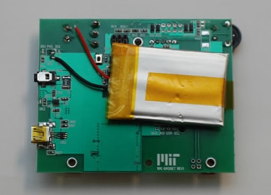
Working from a list of requirements a hardware specification was
developed. Within the defined physical outline an OLED display,
digital compass, Bluetooth radio, USB interface, Li-ion charger, tilt
sensor and motor drive transistors needed to be integrated. The manual
controls included a potentiometer to control the intensity of the
haptic sense motors and an on/off switch. The Li-ion charger will
perform a slow-charge using the 5V supply on the USB connector or
can fast-charge using the power jack.
Software
Low-level drivers and a basic test program were created to demonstrate
the functionality of the hardware. The application program was
created by the team at the
MIT Mobile Experience Lab.
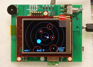
When the gadget is tilted to a horizontal position the waypoints are
displayed on a polar grid. Relative direction is displayed using the
indicator at the center of the grid. Relative distance is displayed
using the grid lines. Using the GPS coordinates and the time data
received from a mobile phone a declination angle correction can be
performed.
Haptic feedback of direction is performed using the vibrating motors
in the neck strap. The potentiometer on the side of the gadget
enables the user to adjust the intensity of the vibration.
Deliverables
- Functional specification and fixed price quote.
- Design summary document (single PDF file). All major design
decisions are documented. Future improvement opportunities are
described. Full schematics and an assembly print. A bill of materials
with hyperlinks to embedded PDF datasheets for all components.
- EDA files. Schematic. PCB. Gerbers.
- Two assembled and functional prototypes.
- Low-level software and a functional test program.
- Ancillary software and hardware. For the Locast Travels a jig was
provided to enable assembly of two boards at a time.
Gallery